English-Speaking Countries Worksheet: Flags, Map and Speaking (Free PDF) 🗺️
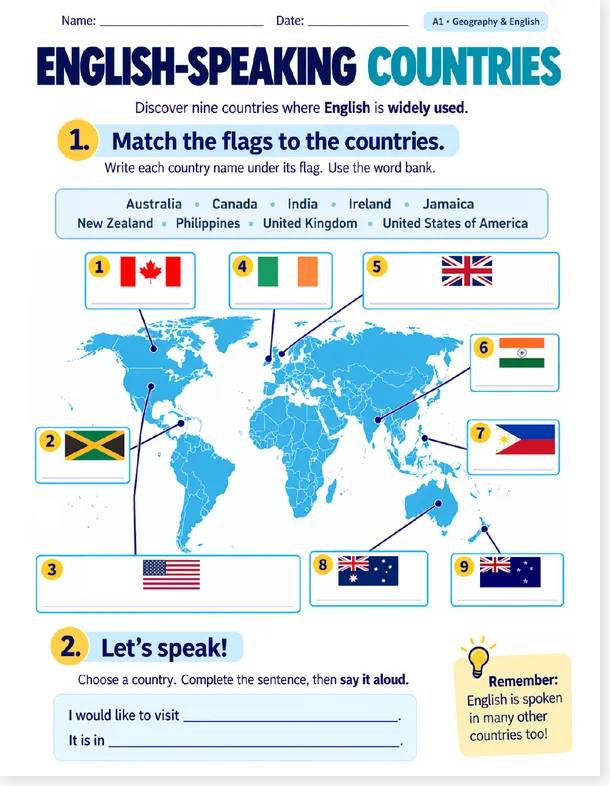
Nine countries where English is widely used, one world map, and nine flags to identify: the student writes each country name under its flag using the word bank, then completes a sentence and says it aloud: « I would like to visit… It is in… » Geography and English in a single page, with a reminder that keeps the door open: English is spoken in many other countries too.
Two versions are available on this page. The new version (2026, v2) comes with numbered flags, a word bank and a speaking activity: its watermarked US Letter PDF is free, and the clean A4 and US Letter PDFs are for Premium members. The old version (2020, v1) is fully free as a PDF, and its editable DOCX is included in the membership.
✨ What the students practise
Four skills on one page: reading the country names in the word bank, locating each country on the world map, writing the name under the right flag, and finally speaking a complete sentence about the country of their choice. The task is short, visual, and it ends with the student’s own voice.
Look at the world map and the nine numbered flags around it.
Write each country name under its flag, using the word bank.
Follow the lines: each flag points to its country on the map.
Complete « I would like to visit… It is in… » and say it aloud.
🆕 The new version (2026): what’s inside
Nine numbered flags connected to a world map, and a word bank with the nine country names to copy under each flag.
A sentence frame to complete and say aloud: « I would like to visit… It is in… » A first step into oral expression.
« English is spoken in many other countries too! » Plus name and date fields at the top, ready for classroom use.
🌍 The nine countries
🕰️ The old version (2020): simple and fully free
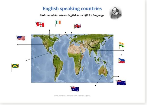
The 2020 worksheet keeps the same idea in its simplest form: a satellite-style world map, nine flags placed around it, and arrows to connect each flag to its country. No word bank, no writing lines: the matching happens with the eyes and the pencil. A small portrait of Shakespeare watches the page from the corner, as a quiet nod to the language.
🆕 Download the new version (v2, 2026)
The watermarked US Letter PDF is free for everyone; the clean A4 and US Letter PDFs are included in the Premium membership.
Preview v2: the world map, the nine numbered flags and the word bank
🎁 Free PDF – US Letter, with watermark
The v2 worksheet, free for everyone, ready to print.
🕰️ Download the old version (v1, 2020)
The PDF is completely free for everyone. The editable DOCX is included in the Premium membership.
Preview v1: the original map with flags and arrows
🎁 Free PDF – A4 (v1, 2020)
The original worksheet, fully free, no watermark.
🎯 Level, grades, and more map work
❓ Frequently asked questions
🗂️ What does the new version contain?
A world map with nine numbered flags, a word bank with the nine country names, a writing task (copy each name under its flag) and a speaking activity: « I would like to visit… It is in… »
🕰️ What is the difference with the 2020 version?
The 2020 version is a simple map with flags and arrows to connect, without word bank or writing lines. The 2026 version adds numbering, a word bank, a writing task and a speaking frame, with a cleaner layout.
🎁 Which versions are free?
The 2020 A4 PDF is fully free, and the 2026 US Letter PDF with watermark is free as well. The clean 2026 PDFs (A4 and US Letter) and the 2020 DOCX are reserved for Premium members.
🎓 What level and grades?
Level A1 in English, with a geography dimension. It fits grades 4 to 6 in mainstream classes, and any ESL group discovering the English-speaking world.
🔑 Are the answers available?
Yes: 1 Canada, 2 Jamaica, 3 United States of America, 4 Ireland, 5 United Kingdom, 6 India, 7 Philippines, 8 Australia, 9 New Zealand. The list is also printed in this article.